Ribeiro Bonito

A nice 10km walk where you will be guided by four caches

Grutas do Paúl

A great set of amazing caves carved into the stone.

Boca das Voltas

Boca das Voltas is a secret viewpoint offering a great scenary. It is ideal to those who enjoy a nice walk in the middle of the forest.

Cais de São Jorge

An historic pier that was once the gate to the north of the island. A beautiful panoramic view at the tip of the pier.

Garganta Funda

A huge 140m waterfall hidden from the common muggle. A test to your corage and a great view at the end.

Arte de Portas Abertas

A simple, old street that was transformed into an art galery. This multicache makes you look closely at each door. Discover its secrets!

O Pescador do Arieiro

This is a funny multi with only two stages that can be done in a short period of time. The cache is located near Pico Arieiro and offers stunning views.

The Cliffs

This multi cache will take you to walk along cliffs that reach from 250m to 500m altitude. The trail will present you with beautiful landscapes and interesting geological phenomena.

Mostrar mensagens com a etiqueta Santana. Mostrar todas as mensagens

sexta-feira, 13 de janeiro de 2017

Geocache of the Week - Senhora da Pedra


GOTW Senhora da Pedra, Madeira Portugal


Senhor da Pedra—Geocache of the Week


Traditional
 
GC2ZWP5
 
by luisftas
 
Difficulty:
 
4
 
Terrain:
 
3.5
Location:
 
Arquipélago da Madeira, Portugal
 
N 32° 50.110 W 016° 54.419


GOTW Senhora da Pedra, Madeira Portugal

Off the southwest coast of Portugal and northwest coast of Africa lies the beautiful archipelago of Madeira. It is the outermost region of the European Union and an autonomous region of Portugal. Known for its idyllic climate, flowing wine, romantic beaches, and sheer cliffs, Madeira is also home to close to 1,200 active geocaches.
You must be thinking, “Geocaching in gloriously warm climate with stunning landscapes and flowing wine—where’s the grit and the character-building adventure of that?!” Luckily, this traditional cache provides a mildly challenging hike with a big pay off in a phenomenal location. Perfect!
You’ll start your journey at the São Jorge (St. George) lighthouse, a sweet little spot to prepare for your trek and take in the ocean views. The lighthouse was, “…designed in 1948 and started to function in 1959. Its structure is a cylindrical tower 14-meters high, and the focus is at an altitude of 271 meters. Its light has a range of 16 miles, and its operation is automated in 1986 after being electrified in 1962.”
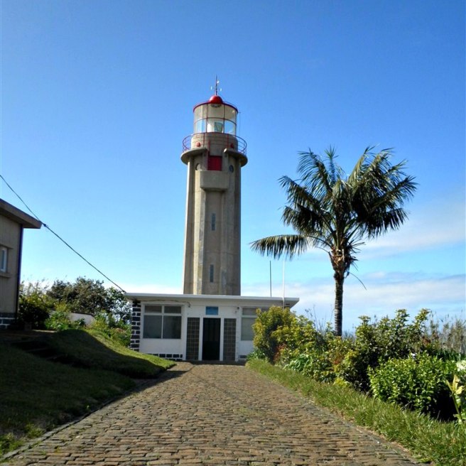

São Jorge (St. George) lighthouse

The next step is to find the path to the geocache. Once you are on the path, you will see why this geocache earned its 3.5 terrain rating. There are many paths—will you take the correct one? Will your path be full of mud with no alternate route? Will you slip and fall in the mud? Will this actually be worth it? Stay strong, intrepid geocachers, because yes, the payoff will be worth it.
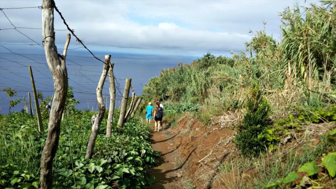

Path to the geocache

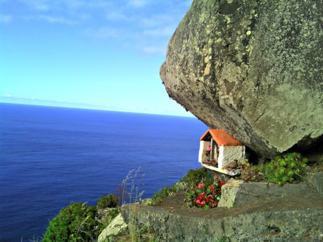
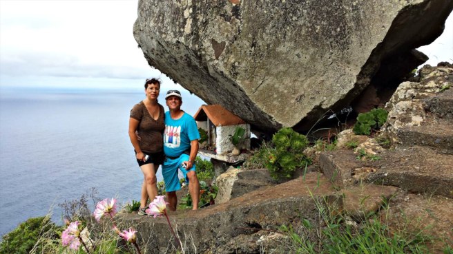
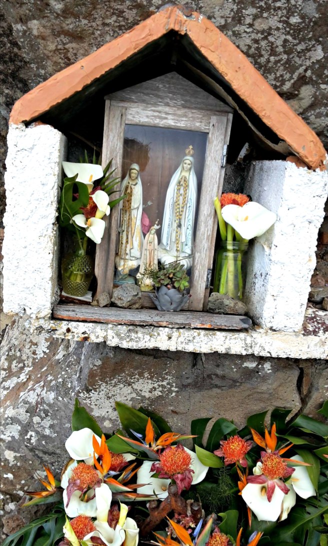
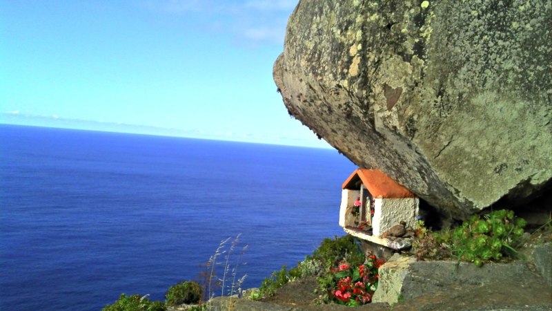
At the end of the path on the very edge of a cliff, you will find a very large rock. Many years ago it broke free from the hills above, rolled down the rugged terrain, then suddenly stopped right on this precipice. This was so amazing and odd that the locals built a small shrine in honor of the “Lady of the Stone” and placed it underneath the boulder. This “monument’ is full of religious statues, candles, flowers, stones, and other knickknacks. It is also a wonderful place for quiet reflection and to sign a logbook.
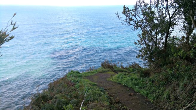

Path to the geocache

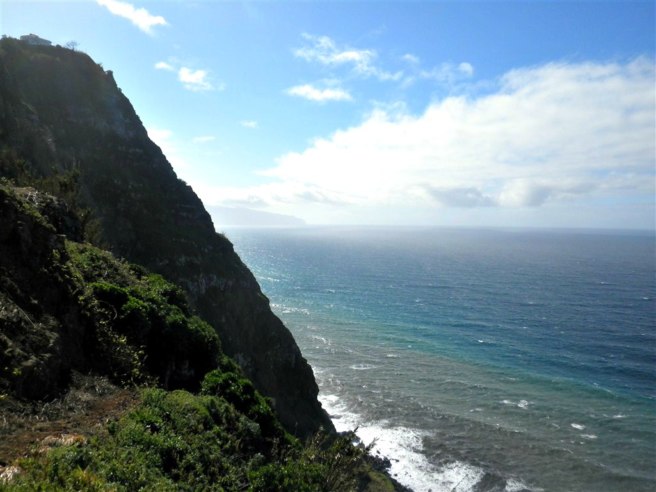
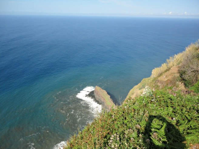
If this amazing rock and little shrine weren’t enough, check out that view! On the left you can see Porto Moniz very far away, while on the right you can look down and see the old pier of São Jorge. Can it get any better than this?
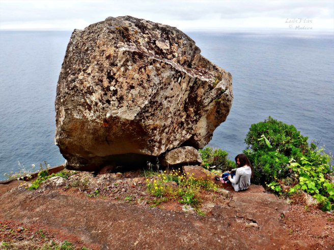

View from above the rock

Recent logs:
Siggi72This is my second time visiting Madeira but the first time with Geocaching. Without geocaching I wouldn’t have seen this “balancing” rock with the small shrine and the great views. Thanks for showing!
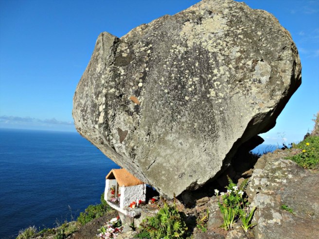

Amazing location for a geocache

ComètesOn our way, we could not miss this cache, that we already bookmarked in France when preparing our trip. Its D/T ratio is the only one missing in on matrix. We first discovered the lighthouse, then went down to GZ. 148 steps later, we were at the right place. A special place, as many ones that we can discover since we are practising geocaching. We found the box with the help of the spoiler. While we were signing the logbook, a rainbow appeared above the Ocean. To celebrate our fully filled matrix? Thank you for this great cache!
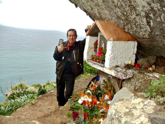

At the shrine under the rock

ED77First we had problems to find the right access and had almost given up. Fortunately we found the right way otherwise we have missed a great adventure and a total crazy place! The path down was a real adventure but at the end worth every step How curious to place a shrine under this huge stone! We enjoyed the mystic and peaceful place, stayed some time staring at the sea This place is worth a favorite point
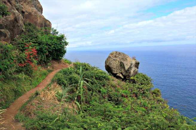

Just before the geocache
Great view and a great experience
The shrine
The shrine
Gorgeous views
Gorgeous views
View to the right
View to the right
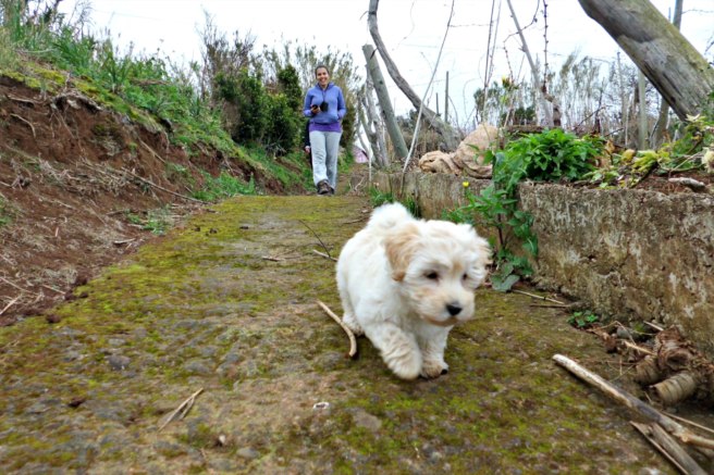
Even pooches love this geocache


Source: https://www.geocaching.com/blog/2016/12/senhor-da-pedra-geocache-of-the-week/ (01/2017)

quarta-feira, 20 de novembro de 2013

Into the Wild

SEMAGRAL - INTO THE WILD


Flag Counter


Lost


Translation: 

LOST


FTF: dandrade, Hugo Pita, Martim Andrade, tojoliveira, Elvio alpHa, ruben&alexandra, escorcios


STF: ricardomariagoncas, horticalheta, residencial.pordosol, cicerocastro, RicardoGonçalvesrady, Gonçalinho


TTF: ...


quinta-feira, 3 de janeiro de 2013

quarta-feira, 7 de novembro de 2012

Boca das Voltas - Video


This video shows the Boca das Voltas viewpoint and part of the trail to get there.
Geocache: http://coord.info/GC2Z19A


quinta-feira, 26 de julho de 2012

Vídeo - Pico Canário GC3R1NJ


Pico Canário GC3R1NJ - (http://coord.info/GC3R1NJ)

Pico Canário

Video: Pico Canário


Esta cache irá te conduzir às redondezas do Pico Canário.
É um percurso que faz a ligação da caminhada Pico Ruivo - Encumeada a São Jorge.
Por ser um percurso pouco frequentado, por vezes a vegetação invade o percurso.

This cache will lead you to the surroundings of Pico Canário.
It is a route that links the Pico Ruivo-Encumeada trail to São Jorge.
As it is a little frequented route, often vegetation invades the route.


O percurso aqui descrito é o que vai de São Jorge até ao Pico Canário.
O percurso é fisicamente desafiante mas não apresenta zonas perigosas.
Após a cache o percurso continua mas o grau de dificuldade aumenta consideravelmente.
Para quem possui um veículo TT, o percurso começa na cache Boca das Voltas.
Existem pessoas que arriscam e levam o seu carro normal até lá, no entanto não é recomendado.

The route described here is: São Jorge - Pico Canário.
The route is physically challenging but does not present the danger zones.
After the cache the route continues but the degree of difficulty increases considerably.
For those with an all terrain vehicle, the route begins in the cache Boca das Voltas.
There are people who risk and take their normal car there, but it is not recommended.


Alguns pontos de referência / Some reference points:

Viewpoint I - Boca das Voltas:  32° 48.593'N  /  16° 57.175'W
Viewpoint II - Vale do Lombo do Urzal:  32° 46.469'N  /  16° 57.398'W
Viewpoint III :  32° 46.492'N  / 16° 57.267'W
Nascente/Spring (Eu bebi e não morri! I drank it and I'm still alive!):  32° 46.484'N  /  16° 57.249'W
Viewpoint IV - Ribeiro Bonito:  32° 46.416'N / 16° 57.113'W

Da zona da cache poderás ter ver o Pico Ruivo mesmo à tua frente e bem lá em baixo o Caldeirão Verde e o Caldeirão do Inferno.

From the area of the cache you will see Pico Ruivo right in front of you and Caldeirão Verde/ Caldeirão do inferno right at your feet.


Atenção:
- São Jorge - Cache - São Jorge: 17 km (distância/distance) , 880m (declive/gradient), 5h30
- Boca das Voltas - Cache - Boca das Voltas: 13 km (distância/distance) , 710m (declive/gradient), 4h30
- O percurso deverá ser feito com boas condições climatéricas e com pouca nebulosidade para que possas usufruir das paisagens proporcionadas.
- Deverás levar água e comida, roupa e calçado apropriados.
- Poderás descarregar aqui o percurso: Pico Canário

Attention:

- São Jorge - Cache - São Jorge: 17 km (distance) , 880m (gradient), 5h30
- Boca das Voltas - Cache - Boca das Voltas: 13 km (distance) , 710m (gradient), 4h30
- The route should be done with good weather conditions and low clouds so you can enjoy the scenery.
- You should bring water and food and appropriate clothing and footwear.
- You can download the track here: Pico Canário


quarta-feira, 6 de julho de 2011

Boca das Voltas

BOCA DAS VOLTAS

video: http://youtu.be/HBgozNzQ6Ps


DO MIRADOURO DA BOCA DAS VOLTAS em São Jorge, Santana, é possível desfrutamos bonitas vistas sobre as Falcãs, Achada da Madeira, Lombo do Urzal e mais ao fundo sobre a foz da Ribeira do Porco .


From BOCA DAS VOLTAS viewpoint in Sao Jorge, Santana, you can enjoy beautiful views of Falcãs, Achada da Madeira, Lombo do Urzal and more deeply on the mouth of the Ribeira Porco.


Se tiveres um veículo TT ou moto esta cache será uma drive-in. Caso contrário deverás deixar o teu carro aqui:
32º49.108
16º56.465

If you have a 4x4 car or moto this cache will be a drive-in. Otherwise you must leave your car here:
32º49.108
16º56.465


Informações / Informations:

Tempo / Time: 45m
Distância / Distance: 2km
Desnível / Gradient: 200m

sexta-feira, 24 de junho de 2011

São Jorge

SÃO JORGE


São Jorge pertence ao concelho de Santana, localizada no extremo norte da ilha, junto da Ponta de São Jorge. A freguesia é limitada, a norte, pelo oceano Atlântico e pela cordilheira do Pico Ruivo e tem uma área de 18, 3 km2. Crê-se que tenha hoje em dia cerca de 1.596 habitantes.

A criação da freguesia remonta ao ano de 1517. Reza a história que uma capela consagrada a São Jorge, depois convertida, no segundo quartel do século XVIII, em igreja paroquial, acabou por determinar o nome da freguesia.  Na realidade, a freguesia de São Jorge teve o seu núcleo primitivo no sítio do Calhau, junto à foz da Ribeira, onde se instituiu uma capela no final do séc. XV. Uma capela que quase ficou destruída por um grande mau tempo em 1660.

Segundo escrevem alguns historiadores, durante mais de quatro séculos, São Jorge funcionou como um dos mais importantes entrepostos comerciais do norte da ilha da Madeira. Na realidade, numa pequena enseada marítima atracavam as embarcações vindas do Funchal e de outras paragens que abasteciam as freguesias de São Jorge e Santana. Mas, a partir do século XX, a construção da nova estrada, acaba com a preponderância da freguesia. A povoação entrou em declínio uma vez que deixou de ser ponto de passagem obrigatório.

St George belongs to the municipality of Santana, in the extreme north of the island near the Ponta de São Jorge and It has about 1,596 inhabitants. The parish is limited to the north by the Atlantic Ocean and by the mountains of Pico Ruivo and has an area of ​​18, 3 km2.

The creation of the parish dates back to 1517. The story goes that a chapel dedicated to St. George, then converted, in the secondquarter of the eighteenth century, in the parish church, eventually determined the name of the parish. In fact, the parish of St. George was born in what is now called Calhau, near the Ribeira de São Jorge, where a chapel was established at the end of the XV century. A chapel that was almost destroyed by severe weather in 1660. 

According to some historians, for more than four centuries, St. George served as one of the most important trading posts in the north of the island of Madeira. Indeed, in a small pier moored vessels coming from Funchal and from other locations who provided the parishes of St. George and Santana. But, in the twentieth century, the construction of new road, ends with the preponderance of the parish. The population has declined since then.


CACHE:

Esta cache leva-nos a 5 lugares a não perder neste lindo local. Deverá procurar a resposta às questões e realizar as simples contas no final.

This cache brings us to 5 places that you should visit in this beautiful location. Look for the answers at the given coordinates and perform simple accounts at the end.


STAGE 1 - MIRADOURO DO LOMBO DO PICO / LOMBO DO PICO VIEWPOINT


O Miradouro do Lombo do Pico em Santana fica localizado no enfiamento da foz da Ribeira de São Jorge, sendo possível se avistar parte da zona balnear que lá existe. Este miradouro oferece uma vista completa sobre as montanhas circundantes à freguesia da Ilha e de São Jorge.

The Lombo do Pico viewpoint in Santana is located next to the mouth of the Ribeira de SãoJorge, being possible to see part of the beach area that is there. This viewpoint offers a full view of the mountains surrounding São Jorge and Ilha.

Quantas mesas existem nestas coordenadas?
How many tables there are at these coordinates?

N32º49.355
W16º54.141


STAGE 2 - MOINHO DE ÁGUA / WATER MILL


Em São Jorge, ainda está actividade o último moinho de água da Madeira. O Moinho de Água de São Jorge conta já com cerca de 300 anos de história, tendo sido recuperado em 2000 e desde aí tem tido grande procura para moer o milho e o trigo. Este moinho é um bom exemplo de preservação; alimentado com as águas da Levada do Rei, faz moer o trigo, o milho, a cevada e o centeio plantados em poios agrícolas de São Jorge.


In São Jorge, it is still active the last water mill in Madeira. The Water Mill of São Jorge now has nearly 300 years of history, having been recovered in 2000 and since then has had high demand for grinding corn and wheat. This mill is a good example of preservation; it is fed by the waters of the Levada do Rei, it grinds wheat, corn, barley and rye grown on the agricultural fields of São Jorge.


Quantas janelas tem o moinho?
How many windows has the mill?

N32º49.201
W16º54.897


STAGE 3 - IGREJA MATRIZ DE SÃO JORGE


Edificada em 1660, no local onde existia uma pequena capela do século XV, foi posteriormente demolida para dar lugar à actual. 

Built in 1660 on the site of a small chapel of the fifteenth century, it was subsequently demolished to make way for the one we see today.

Qual a data que se encontra em cima da porta?
What is the date that is above the door?

N32º49.642
W16º54.411


STAGE 4 - PARQUE DE MERENDAS


Um simples parque de merendas, com uma boa vista sobre o calhau de São Jorge onde nasceu a freguesia.

A simple picnic area with a good view of the Calhau, the birthplace of São Jorge.


Quantos fogareiros existem neste local?
How many brick stoves are on this site?

N32º49.833
W16º54.076


FINAL STAGE: VIGIA


Miradouro de onde podemos observar a costa norte de São Jorge ao Porto Moniz.

Viewpoint from where we can observe the north coast from São Jorge to Porto Moniz.

Final Coordinates:
N 32º 50.0AB
W16º 54.6CD

Answers:
(stage 1) + 3 = A
(stage 2) - 2 = B
(stage 3) - 1753 = C
(stage 4)  = D


Boa Sorte! Good Luck!

Related Posts Plugin for WordPress, Blogger...

The best places to stay in Madeira

Feel like a local, find great places to stay and win a bonus for your first visit!

Geocaching Video