Ribeiro Bonito

A nice 10km walk where you will be guided by four caches

Grutas do Paúl

A great set of amazing caves carved into the stone.

Boca das Voltas

Boca das Voltas is a secret viewpoint offering a great scenary. It is ideal to those who enjoy a nice walk in the middle of the forest.

Cais de São Jorge

An historic pier that was once the gate to the north of the island. A beautiful panoramic view at the tip of the pier.

Garganta Funda

A huge 140m waterfall hidden from the common muggle. A test to your corage and a great view at the end.

Arte de Portas Abertas

A simple, old street that was transformed into an art galery. This multicache makes you look closely at each door. Discover its secrets!

O Pescador do Arieiro

This is a funny multi with only two stages that can be done in a short period of time. The cache is located near Pico Arieiro and offers stunning views.

The Cliffs

This multi cache will take you to walk along cliffs that reach from 250m to 500m altitude. The trail will present you with beautiful landscapes and interesting geological phenomena.

quarta-feira, 16 de maio de 2012

The lime route - Caixa da Cal


Presentation of the DVD "The Lime Route":

The program begins on May 28th (16:00) with a tour to the stone quarries and the rural heritage of Madeira, followed by the presentation of the DVD (16:30) with the historical reconstruction of the lime industry in São Vincente, in the Museum Centre - Rota da Cal.


If you haven't done this cache yet, it is surely a good day to visit this museum:
Caixa da Cal - http://coord.info/GC1FADM

An Alternative History Of Geocaching?


terça-feira, 15 de maio de 2012

Castrinhos & Geocaching


I have recently found a new reason to find Geocaches. 
I have found this card in a geocache. Now I just have to go to the given coordinates and choose which traditional drink I want.


quarta-feira, 9 de maio de 2012

Urzal's Balcony - Video


In this video you'll see some images from the cache: Urzal's Balcony. A physical challenge that will take you to an ancient route once used by Madeirans to reach the south coast.


terça-feira, 8 de maio de 2012

Urzal's Balcony


Video:
http://youtu.be/-bDt2Wldm4U


Lombo do Urzal - Cache: 10km (total) - 4h (total)

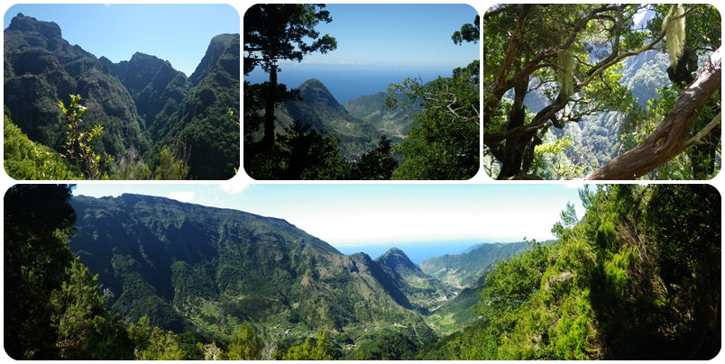
Esta cache está situada numa "varanda" que oferece uma boa panorâmica para o vale do Lombo do Urzal.

This cache is located in a "balcony" that offers good views to the valley of Lombo do Urzal.


O caminho de princípio faz-se suavemente por entre uns terrenos cultivados. Uns palheiros aqui e ali denotam a presença de gado entre portas bem á maneira madeirense.
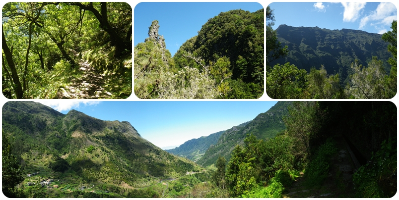
O trilho utilizado pelos nossos antepassados da costa norte para deslocar-se á costa sul e vice versa, a dada altura começa a empinar-se serra acima.

The beginning of the trail is done by gently walking between cultivated land. Some barns here and there denote the presence of livestock near the houses, as usual in Madeira.
The trail used by our ancestors from the north coast to go to the south coast and viceversa, at some point will begin to climb up the mountain.


Pelo caminho encontramos a Levada dos Tornos. Poderás visitar a sua madre e procurar a cache que lá se encontra (http://coord.info/GC35CFX).

Along the way you will find the Levada dos Tornos. You can visit the beginning of the Levada and search for the cache that is there (http://coord.info/GC35CFX).

Então tronco após tronco, curva após curva, caminhamos lentamente com o Lombo do Urzal nas nossas costas sempre cada vez mais distante e mais bonito.

So tree after tree, curve after curve, you will walk slowly with Lombo do Urzal behind your backs ever more distant and more beautiful.

Ao longo do caminho a vegetação que nos acompanha é composta por tis, os loureiros, os paus brancos, os folhados e os adernos. Alguns ranúnculos e algumas estreleiras, fazem a festa da cor por estas paragens em certas alturas do ano.

Along the way you will be accompanied by vegetation that consists of tis, the laurel, whitesticks, puffs and the "adernos". Some buttercups and some "estreleiras", make a feast of color in these parts at certain times of the year.


Se optares por continuar a subir irás chegar à Boca das Torrinhas.
Deverás ter àgua, comida e calçado apropriado. A caminhada deverá ser feita com boas condições climatéricas e é apenas recomendável a pessoas que estejam bem preparadas fisicamente.

If you decide to continue to climb you will reach Boca das Torrinhas.
You should have water, food and appropriate footwear. The walk should be done with good weather conditions and is only recommended to people who are well prepared physically.


Alternatives: Distance (total) / Time (total)

Curral das Freiras (32º 44.580 / 16º 57.976) - Boca das Torrinhas - Cache - return: 12km - 5h
Boca da Corrida (32º 42.663 / 16º 59.240) - Boca das Torrinhas - Cache - return: 19km - 7h
Encumeada (32º 45.255 / 16º 01.120) - Boca das Torrinhas - Cache - return: 15km - 6h
Pico Ruivo (32º 45.609 / 16º 56.603) - Boca das Torrinhas - Cache - return: 13km - 5,5h

sexta-feira, 4 de maio de 2012

A Brief History of Geocaching - Video


Watch the Geocaching.com Presents video "A Brief History of Geocaching" to see how geocaching began.

The history of geocaching stretches back to a single container placed in the hills of Oregon, USA. The date was May 3, 2000. The idea was radical. Treasure hunters would be guided by signals from orbiting satellites. The first geocache was found within days. It sparked a global movement to get off the couch and get outside.

The hobby has spread around the world. There are now more than 1.7 million geocaches. The community of geocaches count more than five million people (fathers, mothers, professionals, astronauts, actors, truckers, pilots, students, teachers... adventurers) in its ranks.


Related Posts Plugin for WordPress, Blogger...

The best places to stay in Madeira

Feel like a local, find great places to stay and win a bonus for your first visit!

Geocaching Video